Kids are natural explorers. They want to know where tigers live, how far away grandma is, and what the world looks like beyond the backyard. A great map feeds that curiosity and plants the seeds for a lifetime of travel.
Today, you aren’t stuck with boring, dusty paper maps. You can find interactive talking maps, scratch-off posters, 3D puzzles, and even bath toys. Whether you are decorating a nursery or helping a middle schooler with geography homework, there is a format that fits your needs.
Let’s help you find the perfect map to spark your child’s next big adventure.
Product Reviews
We analyzed maps for every age, budget, and learning style. Combining parenting insights with hands-on testing and geography teacher feedback, we curated this list to help your child navigate the globe from the comfort of their bedroom.
Illustrated Map Of The World
Best Children's Illustrated Map of the World

This Akros illustrated map does a fantastic job of blending standard geography with visual storytelling. It displays countries and capitals, which you would expect, but it takes things a step further by using colorful illustrations to highlight the unique culture of each region.
Visual learners will love the specific details:
- Famous Landmarks: Spot the Pyramids in Egypt or the Eiffel Tower in France.
- Local Wildlife: Find pandas in China and kangaroos in Australia.
- Cultural Elements: See people in traditional dress, local transportation, and national exports.
We found this approach helps younger children build memory associations. Instead of just memorizing a name, they remember the picture attached to the location. It is a fantastic tool for sparking conversations about how people live in different parts of the world.
Product Specs
| Ages | 3 years and older |
| Size (Inches) | 27.5 x 39 inches |
| Size (CM) | 70 x 99 centimeters |
| Interactive? | No, although you can draw on it in washable markers or with whiteboard markers. |
| Laminated? | No |
Our Ratings
Eric Carle Elementary World Map
Best Kids’ World Map Rug

If you want to introduce geography to the youngest explorers in your house, this area rug is a cozy way to do it. Produced by Home Dynamix, this rug features the beloved art style of Eric Carle. It illustrates where specific animals live using artwork that will feel instantly familiar to fans of his books.
The border features characters from childhood favorites:
- The Very Hungry Caterpillar: A classic recognizable icon.
- The Sloth: From “Slowly, Slowly, Slowly, Said The Sloth.”
This isn’t a high-detail reference map for homework; you won’t find tiny country borders or capital cities here. However, it effectively distinguishes and labels the continents, making it perfect for toddlers and preschoolers. It serves as a soft, engaging spot to sit on the floor, read a book, and start identifying the basic layout of our planet.
Product Specs
| Ages | 2 years and older |
| Size (Inches) | 78 x 114 inches |
| Size (CM) | 198 x 300 centimeters |
| Interactive? | No |
| Laminated? | No |
Our Ratings
Motivation Without Borders Map Poster
Best Kids’ World Map Poster

Motivation Without Borders offers a laminated wall poster designed to withstand the wear and tear of a kid’s room. The durability of the lamination means you don’t have to worry about rips or sticky fingers ruining the map during an enthusiastic geography lesson.
The design focuses on clarity and color coding:
- Color-Coded Continents: Each continent has a distinct color palette, helping kids visually separate regions.
- Varied Shades: Individual countries are shaded differently to make borders pop.
- Cultural Icons: It features cartoon animals, food, and artifacts like Australian boomerangs to add context.
While the cartoonish illustrations are adorable, they might feel a bit young for teenagers. We think this map hits the sweet spot for children aged 3 to 8. It strikes a balance between being a fun decoration and a functional learning tool for early grade schoolers.
Product Specs
| Ages | 3 – 8 years |
| Size (Inches) | 18 x 24 inches |
| Size (CM) | 46 x 61 centimeters |
| Interactive? | No |
| Laminated? | Yes |
Our Ratings
Scratchiez Scratch-Off World Map
Best Scratch Map for Kids

Think of the Scratchiez map as a giant lottery ticket for travelers. It allows your kids to track their adventures in a tactile way. The map starts with a gold foil layer; when you scratch off a country, it reveals a colorful version underneath. It is incredibly satisfying for kids to “unlock” a new country after a family trip or a history lesson.
The kit arrives in a cool telescope-style package and includes everything you need:
- Bonus U.S. Map: A separate map for tracking state-by-state travel.
- Precision Tools: A guitar pick and scratching pen for clean removal.
- Accessories: A microfiber cloth, an erasable gold marker for notes, and a magnifying card.
This is an excellent choice for families who travel frequently or for homeschoolers tracking world history units. The included marker lets kids write notes directly on the map, turning it into a personalized travel diary.
Product Specs
| Ages | 8 years and older |
| Size (Inches) | 17 x 30 inches |
| Size (CM) | 43 x 76 centimeters |
| Interactive? | Yes |
| Laminated? | No |
Our Ratings
HomeEvolution Animal Map Decals
Best Extra Large World Map for Kids

If you have a large, empty wall that needs some life, the HomeEvolution decals are a brilliant solution. Instead of a single poster, these are individual removable vinyl decals that you assemble directly on the wall. This creates a mural effect that looks much more expensive than it is.
We love the flexibility this offers:
- Customizable Layout: You can space the continents out to fit your specific wall size.
- Damage-Free: They peel off without leaving sticky residue, which is great for rentals.
- DIY Project: You can apply them to a painted board if you prefer a movable art piece.
The map features plenty of animals, making it a hit with nature lovers. Don’t worry if your geography skills are rusty; it comes with a guide image so you know exactly where to place the continents. It is a fun weekend project to do with your kids.
Product Specs
| Ages | 8 years and under |
| Size (Inches) | 30 x 39 inches |
| Size (CM) | 70 x 100 centimeters |
| Interactive? | No |
| Laminated? | No |
Our Ratings
Best Learning: My USA Talking Map
Best Interactive World Map for Kids

While this is technically a map of the USA, it is such a powerful tool for geography that it deserves a spot on the list. The Best Learning interactive map features nearly 500 facts covering capitals, climate, history, and fun trivia. It is perfect for helping kids master their home turf before branching out to the rest of the globe.
The interactive features are engaging for auditory learners:
- Touch Response: Pressing a state triggers the map to “speak” facts about that region.
- Quiz Modes: Use the menu to select games that test your child’s knowledge.
- Versatile Use: It works equally well hung on a wall or laid out on the floor.
The only downside is the scope is limited to the 50 states. However, as a supplement to a broader world map, it provides a depth of information that standard posters simply can’t match.
Product Specs
| Ages | 5 years and older |
| Size (Inches) | 24 x 31 inches |
| Size (CM) | 61 x 78 centimeters |
| Interactive? | Yes |
| Laminated? | No |
Our Ratings
A Map Coloring Book
Best Coloring World Map

Not every child has the wall space for a giant map, and some kids learn best when they are creating art. This world map coloring book is the perfect travel companion for road trips or flights. It allows little travelers to engage with geography anywhere they go.
This isn’t a flimsy dollar-store pad:
- High-Quality Paper: The 48-page book uses thick paper that stands up to markers and crayons.
- Detailed Content: It includes marked capitals and countries, plus animals and landmarks to color.
- Creative Learning: Coloring helps cement the shapes and locations of countries in a child’s mind.
It is a great way to keep kids occupied without screens. As they color in the Great Wall of China or the Amazon Rainforest, they are quietly absorbing geography lessons that will stick with them.
Product Specs
| Ages | 5 years and older |
| Size (Inches) | 9 x 12 inches |
| Size (CM) | 23 x 30 centimeters |
| Interactive? | Yes |
| Laminated? | No |
Our Ratings
Sleepwish World Map Bedding
Best World Map Bedding For Kids

If your child dreams of travel, why not let them literally sleep wrapped in the world? Sleepwish offers these bedding sets in Twin, Full, Queen, and King sizes, making them suitable for toddlers and teenagers alike. It is a bold decor choice that instantly themes a room.
There are styles for every age group:
- The Explorer: Cute cartoon animals and simple shapes for younger kids. It lacks borders but is great for general awareness.
- The Geographer: A “traditional” map look with borders, capitals, and mountain ranges. It is essentially a giant, soft reference map.
- The Artist: A funky, multi-colored version on a black background that appeals to tweens and teens.
This bedding turns a functional item into an educational opportunity. It is much more interesting to stare at a map of Africa before falling asleep than a plain blank wall.
Product Specs
| Ages | 3 years and older |
| Size (Inches) | 68 x 86 inches (Twin) 80 x 90 inches (Full) 90 x 90 inches (Queen) 104 x 90 inches (King) |
| Size (CM) | 173 x 218 centimeters (Twin) 203 x 228 centimeters (Full) 228 x 228 centimeters (Queen) 264 x 228 centimeters (King) |
| Interactive? | No |
| Laminated? | No |
Our Ratings
Where on Earth? Atlas
Best Kids’ Atlas

For the bookworms who crave deep dives into data, a wall map might not be enough. The “Where On Earth?” atlas from Dorling Kindersley is a treasure trove of information. While a poster gives you locations, this book gives you the context behind those locations.
It is packed with 3D maps and infographics covering:
- Climate & Biomes: Understanding why certain areas are deserts and others are rainforests.
- Demographics: Information on populations, cultures, and flags.
- Biology: Detailed sections on where different animal species thrive.
This is the most comprehensive guide on our list. It is an invaluable resource for homework help and creates a fantastic bridge for preteens who are ready for more complex geographical concepts.
Product Specs
| Ages | 8 to 12 years |
| Size (Inches) | 10 x 12 inches |
| Size (CM) | 25 x 30 centimeters |
| Interactive? | No |
| Laminated? | No |
Our Ratings
Mudpuppy Map of The World
Best World Map Puzzle

Puzzles are excellent for developing spatial awareness and fine motor skills. This Mudpuppy option combines those benefits with geography. The 78-piece jigsaw assembles into a vibrant 23 x 16.5-inch map, making it a manageable size for a dining room table or a clean floor.
We appreciate the quality construction:
- Sturdy Board: The pieces are thick and durable, designed to withstand repeated assembly.
- Vibrant Print: The colors are bright and engaging, helping kids match pieces by region.
Because of the piece count, it is best suited for elementary-aged kids (around 5 to 9 years old). It is a great rainy-day activity that subtly reinforces where countries are located in relation to one another.
Product Specs
| Ages | 5 years and older |
| Size (Inches) | 23 x 16.5 inches |
| Size (CM) | 58.42 x 41.91 centimeters |
| Interactive? | Yes |
| Laminated? | No |
Our Ratings
USA Toyz LED Illuminated Globe
Best Kids’ Globe

This is a fantastic multi-functional addition to a child’s bedroom. By day, it is a detailed world globe for geography study. By night, it transforms into a soothing night light that displays star constellations.
It offers a 3-in-1 experience:
- Day View: Clearly marked countries, capitals, and natural features.
- Night View: An illuminated sensor shows 88 major star constellations.
- Digital App: It includes an accompanying app for extra learning (though the globe works fine without it).
The stand is stable and tip-resistant, which is crucial for kids’ items. Just keep in mind that the LED feature requires access to a power outlet. It is a magical way to get kids interested in both the earth below and the sky above.
Product Specs
| Ages | 3 years and older |
| Size (Inches) | 9-inch diameter x 13.5 inches tall |
| Size (CM) | 23-centimeter diameter x 34 centimeters tall |
| Interactive? | Yes |
| Laminated? | No |
Our Ratings
World Map Animal Tapestry
Best Children's World Map with Animals

Sometimes you just want something soft, safe, and visually stimulating for a nursery. This tapestry is a giant fabric wall hanging that features simple, adorable animal cartoons. It adds a pop of color and a theme to a room without the hassle of wallpaper or heavy frames.
Here is why it works for nurseries:
- Soft Aesthetic: The fabric look is warmer and cozier than a glossy paper poster.
- Versatile: It works as a wall hanging, a bedspread, or even a festive tablecloth for a birthday party.
- Simple Content: It names continents but skips complex country borders, keeping it uncluttered for little eyes.
If you need a rigorous educational tool, look elsewhere. But if you want a cute, budget-friendly piece of decor that introduces the concept of a big world to a toddler, this is a lovely choice.
Product Specs
| Ages | 3 years and older |
| Size (Inches) | 40 x 60 inches |
| Size (CM) | 102 x 152 centimeters |
| Interactive? | No |
| Laminated? | No |
Our Ratings
Melissa & Doug Travel Rug
Best World Map for Toddlers

Melissa & Doug are pros at open-ended play, and this rug is no exception. It isn’t just a map; it is a play surface designed to spark imagination. The set comes with three wooden vehicles (a boat, plane, and car) so your child can physically “drive” or “fly” across the oceans.
The kit includes fun extras:
- Wooden Vehicles: Durable toys that fit perfectly on the rug’s paths.
- Passport Set: A toy passport with stickers lets kids stamp where they have “visited.”
- Clear Labels: Continents and oceans are labeled clearly for early readers.
This is fantastic for kinetic learners who need to move to learn. It is durable enough for a playroom and, once your own kids outgrow it, it makes a wonderful donation to a kindergarten classroom.
Product Specs
| Ages | 3 to 6 years |
| Size (Inches) | 39 x 36 inches |
| Size (CM) | 99 x 91 centimeters |
| Interactive? | Yes |
| Laminated? | No |
Our Ratings
Alex USA Map in The Tub
Best Bath Map

Who says geography has to stop at the bathroom door? This foam puzzle map turns bath time into learning time. The set includes 29 pieces that float in the water and, when wet, stick easily to tile walls or the side of the tub.
It is great for sensory play:
- Easy Assembly: The chunky foam pieces are easy for wet hands to grab and snap together.
- Visual Cues: It features fun illustrations of landmarks and local animals to help identify regions.
- Storage: It comes with a suction-cup mesh bag to keep the pieces from taking over your bathroom.
While this specific model focuses on the USA, it teaches the fundamental skill of piecing together a map. It is a low-pressure, fun way to get kids familiar with state shapes and locations while they scrub up.
Product Specs
| Ages | 3 years and older |
| Size (Inches) | 11 x 21 inches |
| Size (CM) | 28 x 53 centimeters |
| Interactive? | Yes |
| Laminated? | No |
Our Ratings
Learning Resources Kids’ Puzzle Globe
Best Continents Map for Kids
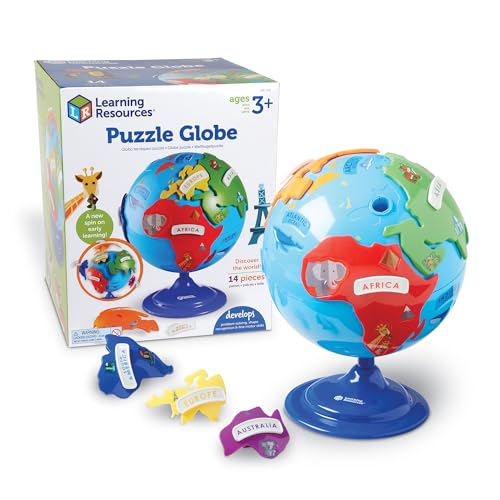
For tactile learners, a flat map can be hard to conceptualize. This 3D puzzle globe solves that by letting kids physically handle the continents. The brightly colored plastic pieces are chunky and designed specifically for small, preschool-sized hands.
The main benefits include:
- Self-Correction: Each continent piece fits into a specific shape on the globe, like a puzzle, so kids can’t place them wrong.
- Durability: The sturdy plastic construction can survive being dropped (or thrown) during play.
- Labels: It includes simple animal and landmark pictures on the continents.
By removing and replacing the pieces, children develop a better understanding of where continents sit on the globe. It is an excellent introduction to Earth science for ages 3 and up.
Product Specs
| Ages | 3 years and older |
| Size (Inches) | 8 inches diameter x 10 inches high |
| Size (CM) | 21 centimeters diameters x 25 centimeters high |
| Interactive? | Yes |
| Laminated? | No |
Our Ratings
| Product | Best | Ages | Size | Interactive? | Laminated? |
| Illustrated Map Of The World | Illustrated Map | 3 years & older | 27.5 x 39″ | No | No |
| Eric Carle Elementary World Map | Rug | 2 years & older | 78 x 114″ | No | No |
| Motivation Without Borders Map Poster | Poster | 3 – 8 years | 18 x 24″ | No | Yes |
| Scratchiez Scratch-Off World Map | Scratch Map | 8 years & older | 17 x 30″ | Yes | No |
| HomeEvolution Animal Map Decals | Extra Large | 8 years & under | 30 x 39″ | No | No |
| Best Learning: Talking U.S Map | Interactive | 5 years & older | 24 x 31″ | Yes | No |
| A Map Coloring Book | Coloring | 5 years & older | 9 x 12″ | Yes | No |
| Sleepwish World Map Bedding | Bedding | 3 years & older | 68 x 86″ | No | No |
| Where on Earth? Atlas | Atlas | 8 to 12 years | 10 x 12″ | No | No |
| Mudpuppy Map of The World Puzzle | Puzzle | 5 years & older | 23 x 16.5″ | Yes | No |
| USA Toyz LED Illuminated Globe | Globe | 3 years & older | 9 x 13.5″ | Yes | No |
| World Map Animal Tapestry | Animals | 3 years & older | 40 x 60″ | No | No |
| Melissa & Doug Travel Rug | Toddlers | 3 to 6 years | 39 x 36″ | Yes | No |
| Alex USA Map in The Tub | Bath | 3 years & older | 11 x 21″ | Yes | No |
| Learning Resources Kids’ Puzzle Globe | Continents | 3 years & older | 8 x 10″ | No | No |
FAQs
At What Age Can Kids Understand Maps?
Children can start understanding basic map concepts as early as age 3 or 4. At this stage, focus on simple picture maps or rugs with clear continents and animals. By age 6 or 7, they can typically grasp more complex ideas like borders, cardinal directions, and the difference between countries and continents.
Why Are Maps Good for Kids?
Maps help develop spatial thinking skills, which are crucial for math and science later in life. They also foster curiosity about the world, teach relative location (near vs. far), and help children understand their place in a global context. Plus, they make history and social studies much easier to visualize.
What Is the Difference Between a Globe and a Map?
A globe is a 3D spherical representation of the Earth, which provides the most accurate view of distances and sizes without distortion. A map is a 2D flat representation. While maps are more convenient and can show more detail, they inevitably distort the size or shape of landmasses (especially near the poles) to flatten the image.
How Do I Teach My Child To Read a Map?
Start small. Begin with a map of their bedroom or house, then move to your neighborhood. When looking at a world map, start by finding your home country. Then, point out where relatives live or where favorite animals come from. Using a “You Are Here” sticker can help ground them before they explore further.
Where Will They Go?
Maps are more than just wall decor; they are launchpads for imagination. They turn abstract concepts into real places and show children that they are part of a much bigger, exciting world.
Whether you choose a high-tech talking globe or a simple scratch-off poster, you are giving your child a gift that grows with them. Pick the one that fits your space and budget, and get ready to answer a lot of questions about where zebras live.